From the Atlantic to the Mediterranean: The Weather. Learning to adjust. And just learning.
On moving to Valencia last year to try my hand at flying a Search and Rescue helicopter in Spain, the predominantly anti-cyclonic picture of Spain’s Mediterranean-facing east coast presented an entirely new meteorological situation to me. “SAR in the sunshine, what’s not to like,” was one of the tongue in cheek comments that sent me on my way from the UK. And it’s true; the days where CAVOK doesn’t make up most of the TAF seem few and far between.
But, for a pilot who associated all the ‘gotchas’ of meteorology with the ‘bad’ weather conditions of the UK – changeable weather, low cloud, heavy precipitation, strong winds, and high seas – I have had to accept a change of mindset. I have come to learn that ready sunshine and slack pressure gradients can still present their own challenges to an unsuspecting aviator who might be more accustomed – and even comfortable – with Instrument Meteorological Conditions.
One of the near constants of my flying career – the wind -has become less dependable and more fickle. The Atlantic-facing shoreline of the UK is rarely short of a pressure gradient and if you ask most people what the prevailing wind direction is in Britain they will surely tell you ‘south-west’. If you discount topographic effects as it crosses the country from west to east this is certainly the case. The dominance of our prevailing south-westerly is evident from the fact that even as aviators we don’t give our different winds names to distinguish them from each other.
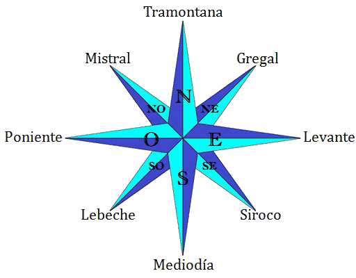
On Spain’s eastern coast, along what is known as the Costa Blanca and the Costa Brava the prevailing winds are more changeable. Each has a name, and even the general public are familiar with these and the kind of weather and temperature changes that each brings. They are known as the Mistral and the Tramontana from the north, the Levante from the East and the Poniente from the West. Strangely enough however for a part of the world that is seemingly so wind-conscious, one of the things that struck me almost as soon as I started to fly here was how little of it there seems to be.
Of course there is wind but, not only does it change sporadically with the pressure patterns, it changes direction and comes and goes throughout the day. With strong solar heating and a steep mountainous coastline which faces the sun, from the Costa Blanca northwards, and unaffected by Africa, the sea breeze is often by far the most significant factor. On parts of this coast, almost regardless of the morning wind, the sea breeze often sets in around early to mid-afternoon from a south-easterly direction. Sometimes it lasts for a few hours and reaches 20-25 knots, extending to some 15-20 miles offshore. At other times it dies out fairly quickly and will scarcely get to 10 knots. In terms of local time it seems to come in fairly late in the day between 1600 or 1700 hours but this is due to the fact that in reality it is only 1400 or 1500 in solar time, so still only 2 hours or so after solar noon.
Valencia sits in a relatively sheltered position well to the south of the strongest effects of the Mistral and Tramontana that flow down from the south of France, and well north of the funnelling effects of the Straits of Gibraltar which gives the wind its strength on the Costa del Sol and places like Tarifa, the famous kite-surfing Mecca. By shortly after dark it is not unusual for the wind to disappear almost altogether, and for operational reasons, this is when SAR training usually takes place.
One of the more challenging elements of adjusting to these conditions for a pilot brought up on the Atlantic coast is the problem of wind finding, where you require a greater flexibility and a more questioning mindset in the set of up your approach, particularly in the later stages where the influence of the wind in low wind conditions starts to become more evident. It is not unusual at wind speeds below 5 knots for the wind direction to change significantly within a short space of time and over relatively short distances.
The skill lies in finding an into wind position by looking for all available cues at the bottom of an approach over the sea, including the position of the downwash, judging whether the aircraft has come to the hover in a slightly left or right wing low position, and the resulting need to introduce left or right pedal to correct until it settles comfortably. Once established in the hover slack wind conditions present the twin evils of higher hover torque and a few tonnes of rotor wash hitting the sea directly below the aircraft, which could easily drown a person in the water, and complicates the task of hoisting to small and even medium sized vessels.
Hoisting in safe single engine conditions even for training is unusual until the later stages of a flight, even in the abundantly powered AW139, and expectations as to what constitutes a flyaway condition in the event of engine failure are tweaked to figures up to 10% higher than those being used by colleagues enjoying the colder and windier conditions on the North Sea. Acceptable risk in this area has to be adjusted to take account for the art of the possible.
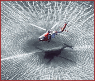
Rescue techniques have also been developed to take into account the fierce downwash that can hamper hoisting operations in still wind conditions. Hover heights are stepped up, and a hi-line is almost always used to guide persons and equipment on the cable to a deck or a cliff situation, allowing the helicopter to remain in a position stood-off from the overhead to alleviate the worst effects of the punishing downdraft. Even so, the position of the ‘donut’ of air pushing down and out from the helicopter has the effect of turning and drifting smaller vessels in unpredictable ways, which can complicate the job of the pilot in keeping station and maintaining effective visual references. In situations where it would be too difficult or risky to con the aircraft directly overhead the target it is the job of the rescue swimmer to do the hard work of fighting their way through the wind and waves to reach the victim or the target vessel under their own power. They have my utmost respect for what they do to earn their keep.
Not everybody thinks of mountains when they think of Spain but it is in fact one of the most mountainous countries in Europe. Neither would most foreigners identify the Mediterranean coast as a part of Spain which is particularly mountainous. I thought I knew better than that, well acquainted as I was with the trip up and down the coast between the cities of Alicante and Valencia. But it wasn’t until I started flying here that I realised the highest obstacle between the two cities reaches a surprising 5304ft above mean sea level, requiring a safety altitude of 7500+ feet. This is a figure which seems very high up for a maritime helicopter pilot and is not far off the ceiling of the aircraft in some conditions. Skafell Pike, England’s highest peak, comes up over 2000 feet short. In summer, when temperatures often climb in to the high thirties, the density altitude climbs too and can become a factor if operating at high all up mass.

Even close to the coast there are significant local wind effects; many of them orographic, as well as the anabatic and katabatic flows associated with mountainous terrain. Flying along the coast on a strong wind day with prevailing westerlies, a well-extended line of fierce-looking ‘cats’ paws’ can be seen marking the water downwind of the steeply rising coastline. These can easily reach a mile offshore.
Downdrafts and the severe turbulence present in standing waves are a feature which occur on a scale that you would unlikely encounter in all but the most severe areas of Britain’s more gently undulating topography. In 2019 a six and a half tonne AW139 SAR helicopter was turned on its side in flight here in Spain and the windows knocked out by what is likely to be judged a severe turbulence event and illustrates just how powerful some of these forces can be. The aircraft and crew survived an emergency landing and the accident is still under investigation.
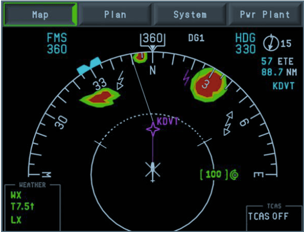
On the occasions that the prevailing CAVOK in the TAF makes way for a cloud group, it is no longer the low level stratiform cloud that I was used to in West Cornwall. Instead, towering cumuli and cumulonimbus tend to be the things to look out for. With strong heating, vigorous convection is always possible, and the warm water of the Mediterranean will ensure that there is always plenty of latent heat. Thunderstorms are the result. These can be massive and dangerous, and if they pop up in the wrong place at the wrong time could even result in a no-go decision for a SAR mission. My previous belief that the weather radar – in anything other than ground-mapping mode below 500 feet – was for airline pilots has given way to a realisation I have a new tool in the cockpit that it is well worth paying some attention to.
I have been a helicopter pilot long enough now to know that when it comes to flying there is always more to learn. I’m also far enough through life to understand the infinite value of new experiences. Moving to fly in Spain has illustrated this as never before, and has already taught me many new things in the cockpit and beyond. Truth be told, when I first looked ahead at the challenges it might bring I think I was unable to project beyond the struggles I might have with language, communication, and culture. I knew it would take me well beyond my comfort zone, and that it did. Sometimes it still does. And looking ahead it certainly will still. But knowing that after such a short time I can look back in the knowledge that I have grown as an aviator, and thinking about everything that I wouldn’t know if I hadn’t taken the leap, already makes it all worthwhile. SAR in the sunshine: what’s not to like?!
*The content and the views expressed in this article are all my own and do not represent those of my employer or any related parties.
